|
|
|||||||||||||||||
| Point ID: 7696 | Downloads | Plots | Site Data | Code: 15453500 |
|
|
|||||||||||||||||
| Download | |
|---|---|
| Site Descriptor Information | Site Time Series Data |
| Link to all available data | |
| View: | Time Series | All |
| Units: | mm |
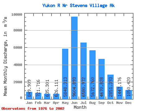
| Statistic | Jan | Feb | Mar | Apr | May | Jun | Jul | Aug | Sep | Oct | Nov | Dec | Annual |
|---|---|---|---|---|---|---|---|---|---|---|---|---|---|
| Mean | 849.91 | 721.72 | 635.30 | 626.11 | 5848.31 | 9604.89 | 6580.97 | 5672.76 | 4670.83 | 2851.39 | 1447.18 | 1050.42 | 3415.18 |
| Standard Deviation | 122.81 | 97.20 | 90.32 | 101.14 | 1979.79 | 2563.66 | 967.49 | 953.88 | 823.41 | 573.37 | 257.31 | 164.98 | 340.59 |
| Min | 666.86 | 547.12 | 453.07 | 419.09 | 2567.77 | 6422.26 | 5065.88 | 4032.32 | 3298.91 | 2133.39 | 977.78 | 758.04 | 2702.21 |
| Max | 1066.98 | 910.10 | 820.34 | 797.69 | 10562.18 | 17389.38 | 9067.06 | 7222.62 | 6499.66 | 4658.58 | 1972.84 | 1371.95 | 4102.33 |
| Coefficient of Variation | 0.14 | 0.14 | 0.14 | 0.16 | 0.34 | 0.27 | 0.15 | 0.17 | 0.18 | 0.20 | 0.18 | 0.16 | 0.10 |
 Return to R-Arctic Net Home Page