|
|
|||||||||||||||||
| Point ID: 7696 | Downloads | Plots | Site Data | Code: 15453500 |
|
|
|||||||||||||||||
| Download | |
|---|---|
| Site Descriptor Information | Site Time Series Data |
| Link to all available data | |
| View: | Time Series | All |
| Units: | m3/s |
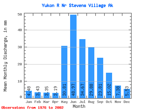
| Statistic | Jan | Feb | Mar | Apr | May | Jun | Jul | Aug | Sep | Oct | Nov | Dec | Annual |
|---|---|---|---|---|---|---|---|---|---|---|---|---|---|
| Mean | 4.48 | 3.46 | 3.35 | 3.19 | 30.80 | 48.97 | 34.66 | 29.88 | 23.81 | 15.02 | 7.38 | 5.53 | 212.00 |
| Standard Deviation | 0.65 | 0.47 | 0.48 | 0.52 | 10.43 | 13.07 | 5.10 | 5.02 | 4.20 | 3.02 | 1.31 | 0.87 | 21.14 |
| Min | 3.51 | 2.63 | 2.39 | 2.14 | 13.53 | 32.74 | 26.68 | 21.24 | 16.82 | 11.24 | 4.99 | 3.99 | 167.74 |
| Max | 5.62 | 4.37 | 4.32 | 4.07 | 55.63 | 88.66 | 47.76 | 38.04 | 33.14 | 24.54 | 10.06 | 7.23 | 254.65 |
| Coefficient of Variation | 0.14 | 0.14 | 0.14 | 0.16 | 0.34 | 0.27 | 0.15 | 0.17 | 0.18 | 0.20 | 0.18 | 0.16 | 0.10 |
 Return to R-Arctic Net Home Page