|
|
|||||||||||||||||
| Point ID: 7681 | Downloads | Plots | Site Data | Code: 15476000 |
|
|
|||||||||||||||||
| Download | |
|---|---|
| Site Descriptor Information | Site Time Series Data |
| Link to all available data | |
| View: | Time Series | All |
| Units: | mm |
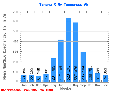
| Statistic | Jan | Feb | Mar | Apr | May | Jun | Jul | Aug | Sep | Oct | Nov | Dec | Annual |
|---|---|---|---|---|---|---|---|---|---|---|---|---|---|
| Mean | 69.85 | 66.17 | 64.25 | 76.80 | 234.78 | 417.11 | 629.19 | 587.08 | 295.10 | 138.75 | 87.59 | 74.36 | 227.44 |
| Standard Deviation | 9.29 | 8.65 | 9.17 | 16.57 | 55.51 | 108.60 | 98.07 | 108.87 | 60.42 | 26.82 | 14.14 | 10.60 | 28.35 |
| Min | 48.11 | 45.28 | 39.62 | 51.59 | 112.04 | 247.97 | 455.91 | 335.64 | 182.68 | 73.58 | 62.06 | 54.42 | 170.96 |
| Max | 89.09 | 87.73 | 87.73 | 126.70 | 369.03 | 705.52 | 983.42 | 843.62 | 425.92 | 201.01 | 125.65 | 100.78 | 294.88 |
| Coefficient of Variation | 0.13 | 0.13 | 0.14 | 0.22 | 0.24 | 0.26 | 0.16 | 0.18 | 0.20 | 0.19 | 0.16 | 0.14 | 0.12 |
 Return to R-Arctic Net Home Page