|
|
|||||||||||||||||
| Point ID: 7681 | Downloads | Plots | Site Data | Code: 15476000 |
|
|
|||||||||||||||||
| Download | |
|---|---|
| Site Descriptor Information | Site Time Series Data |
| Link to all available data | |
| View: | Time Series | All |
| Units: | m3/s |
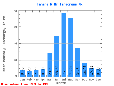
| Statistic | Jan | Feb | Mar | Apr | May | Jun | Jul | Aug | Sep | Oct | Nov | Dec | Annual |
|---|---|---|---|---|---|---|---|---|---|---|---|---|---|
| Mean | 8.45 | 7.29 | 7.77 | 8.99 | 28.39 | 48.82 | 76.09 | 71.00 | 34.54 | 16.78 | 10.25 | 8.99 | 324.15 |
| Standard Deviation | 1.12 | 0.95 | 1.11 | 1.94 | 6.71 | 12.71 | 11.86 | 13.17 | 7.07 | 3.24 | 1.66 | 1.28 | 40.41 |
| Min | 5.82 | 4.99 | 4.79 | 6.04 | 13.55 | 29.02 | 55.13 | 40.59 | 21.38 | 8.90 | 7.26 | 6.58 | 243.65 |
| Max | 10.77 | 9.67 | 10.61 | 14.83 | 44.63 | 82.58 | 118.93 | 102.02 | 49.85 | 24.31 | 14.71 | 12.19 | 420.26 |
| Coefficient of Variation | 0.13 | 0.13 | 0.14 | 0.22 | 0.24 | 0.26 | 0.16 | 0.18 | 0.20 | 0.19 | 0.16 | 0.14 | 0.12 |
 Return to R-Arctic Net Home Page