|
|
|||||||||||||||||
| Point ID: 7678 | Downloads | Plots | Site Data | Code: 15389500 |
|
|
|||||||||||||||||
| Download | |
|---|---|
| Site Descriptor Information | Site Time Series Data |
| Link to all available data | |
| View: | Time Series | All |
| Units: | mm |
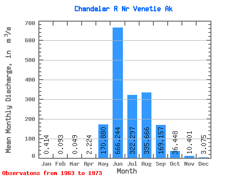
| Statistic | Jan | Feb | Mar | Apr | May | Jun | Jul | Aug | Sep | Oct | Nov | Dec | Annual |
|---|---|---|---|---|---|---|---|---|---|---|---|---|---|
| Mean | 0.41 | 0.09 | 0.05 | 2.22 | 170.88 | 666.24 | 322.30 | 335.67 | 169.16 | 36.45 | 10.40 | 3.08 | 136.57 |
| Standard Deviation | 1.01 | 0.19 | 0.10 | 2.96 | 169.26 | 216.76 | 101.38 | 165.02 | 85.39 | 20.40 | 8.48 | 3.46 | 31.12 |
| Min | 0.00 | 0.00 | 0.00 | 0.01 | 2.17 | 265.51 | 161.73 | 150.53 | 75.98 | 8.49 | 0.52 | 0.14 | 79.50 |
| Max | 3.28 | 0.58 | 0.28 | 8.69 | 523.55 | 954.84 | 495.53 | 567.13 | 382.62 | 65.71 | 26.29 | 11.49 | 182.16 |
| Coefficient of Variation | 2.45 | 2.08 | 1.95 | 1.33 | 0.99 | 0.33 | 0.32 | 0.49 | 0.51 | 0.56 | 0.81 | 1.13 | 0.23 |
 Return to R-Arctic Net Home Page