|
|
|||||||||||||||||
| Point ID: 7678 | Downloads | Plots | Site Data | Code: 15389500 |
|
|
|||||||||||||||||
| Download | |
|---|---|
| Site Descriptor Information | Site Time Series Data |
| Link to all available data | |
| View: | Time Series | All |
| Units: | m3/s |
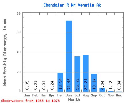
| Statistic | Jan | Feb | Mar | Apr | May | Jun | Jul | Aug | Sep | Oct | Nov | Dec | Annual |
|---|---|---|---|---|---|---|---|---|---|---|---|---|---|
| Mean | 0.05 | 0.01 | 0.01 | 0.24 | 18.94 | 71.46 | 35.72 | 37.20 | 18.14 | 4.04 | 1.12 | 0.34 | 178.37 |
| Standard Deviation | 0.11 | 0.02 | 0.01 | 0.32 | 18.76 | 23.25 | 11.23 | 18.29 | 9.16 | 2.26 | 0.91 | 0.38 | 40.64 |
| Min | 0.00 | 0.00 | 0.00 | 0.00 | 0.24 | 28.48 | 17.92 | 16.68 | 8.15 | 0.94 | 0.06 | 0.02 | 103.83 |
| Max | 0.36 | 0.06 | 0.03 | 0.93 | 58.02 | 102.42 | 54.92 | 62.85 | 41.04 | 7.28 | 2.82 | 1.27 | 237.91 |
| Coefficient of Variation | 2.45 | 2.08 | 1.95 | 1.33 | 0.99 | 0.33 | 0.32 | 0.49 | 0.51 | 0.56 | 0.81 | 1.13 | 0.23 |
 Return to R-Arctic Net Home Page