|
|
|||||||||||||||||
| Point ID: 7664 | Downloads | Plots | Site Data | Code: 71268 |
|
|
|||||||||||||||||
| Download | |
|---|---|
| Site Descriptor Information | Site Time Series Data |
| Link to all available data | |
| View: | Time Series | All |
| Units: | mm |
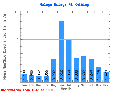
| Statistic | Jan | Feb | Mar | Apr | May | Jun | Jul | Aug | Sep | Oct | Nov | Dec | Annual |
|---|---|---|---|---|---|---|---|---|---|---|---|---|---|
| Mean | 1.13 | 0.95 | 0.86 | 0.87 | 3.23 | 8.61 | 5.86 | 3.34 | 3.63 | 3.24 | 2.13 | 1.42 | 2.94 |
| Standard Deviation | 0.23 | 0.19 | 0.16 | 0.19 | 1.74 | 1.85 | 2.09 | 0.82 | 0.98 | 0.99 | 0.65 | 0.39 | 0.46 |
| Min | 0.73 | 0.59 | 0.53 | 0.48 | 0.81 | 4.71 | 3.02 | 1.74 | 1.73 | 1.43 | 1.11 | 0.80 | 1.96 |
| Max | 1.74 | 1.37 | 1.20 | 1.31 | 6.67 | 13.50 | 11.40 | 4.95 | 6.67 | 5.90 | 4.12 | 2.31 | 4.23 |
| Coefficient of Variation | 0.20 | 0.20 | 0.18 | 0.23 | 0.54 | 0.21 | 0.36 | 0.24 | 0.27 | 0.30 | 0.31 | 0.27 | 0.15 |
 Return to R-Arctic Net Home Page