|
|
|||||||||||||||||
| Point ID: 7664 | Downloads | Plots | Site Data | Code: 71268 |
|
|
|||||||||||||||||
| Download | |
|---|---|
| Site Descriptor Information | Site Time Series Data |
| Link to all available data | |
| View: | Time Series | All |
| Units: | m3/s |
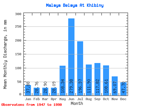
| Statistic | Jan | Feb | Mar | Apr | May | Jun | Jul | Aug | Sep | Oct | Nov | Dec | Annual |
|---|---|---|---|---|---|---|---|---|---|---|---|---|---|
| Mean | 37.87 | 29.00 | 28.90 | 28.10 | 108.32 | 279.37 | 196.35 | 111.89 | 117.83 | 108.58 | 69.05 | 47.69 | 1160.90 |
| Standard Deviation | 7.74 | 5.78 | 5.24 | 6.31 | 58.42 | 60.15 | 70.07 | 27.45 | 31.68 | 33.10 | 21.21 | 12.98 | 179.78 |
| Min | 24.47 | 18.02 | 17.76 | 15.57 | 27.15 | 152.79 | 101.22 | 58.32 | 56.12 | 47.93 | 36.01 | 26.81 | 775.50 |
| Max | 58.32 | 41.84 | 40.22 | 42.50 | 223.56 | 437.95 | 382.09 | 165.91 | 216.38 | 197.75 | 133.66 | 77.42 | 1670.49 |
| Coefficient of Variation | 0.20 | 0.20 | 0.18 | 0.23 | 0.54 | 0.21 | 0.36 | 0.24 | 0.27 | 0.30 | 0.31 | 0.27 | 0.15 |
 Return to R-Arctic Net Home Page