|
|
|||||||||||||||||
| Point ID: 764 | Downloads | Plots | Site Data | Code: 07GF008 |
|
|
|||||||||||||||||
| Download | |
|---|---|
| Site Descriptor Information | Site Time Series Data |
| Link to all available data | |
| View: | Time Series | All |
| Units: | mm |
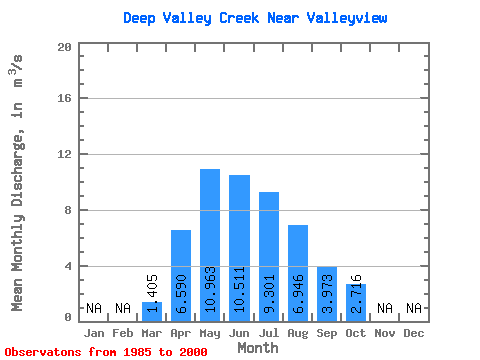
| Statistic | Jan | Feb | Mar | Apr | May | Jun | Jul | Aug | Sep | Oct | Nov | Dec | Annual |
|---|---|---|---|---|---|---|---|---|---|---|---|---|---|
| Mean | 1.41 | 6.59 | 10.96 | 10.51 | 9.30 | 6.95 | 3.97 | 2.72 | |||||
| Standard Deviation | 1.22 | 3.73 | 5.93 | 6.81 | 7.65 | 10.07 | 2.93 | 1.99 | |||||
| Min | 0.63 | 3.06 | 2.40 | 2.08 | 1.46 | 1.23 | 1.07 | 0.96 | |||||
| Max | 4.59 | 13.00 | 23.20 | 26.20 | 29.50 | 38.30 | 10.00 | 8.21 | |||||
| Coefficient of Variation | 0.86 | 0.57 | 0.54 | 0.65 | 0.82 | 1.45 | 0.74 | 0.73 |
 Return to R-Arctic Net Home Page