|
|
|||||||||||||||||
| Point ID: 764 | Downloads | Plots | Site Data | Code: 07GF008 |
|
|
|||||||||||||||||
| Download | |
|---|---|
| Site Descriptor Information | Site Time Series Data |
| Link to all available data | |
| View: | Time Series | All |
| Units: | m3/s |
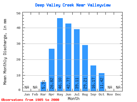
| Statistic | Jan | Feb | Mar | Apr | May | Jun | Jul | Aug | Sep | Oct | Nov | Dec | Annual |
|---|---|---|---|---|---|---|---|---|---|---|---|---|---|
| Mean | 5.91 | 26.82 | 46.09 | 42.77 | 39.10 | 29.20 | 16.17 | 11.42 | |||||
| Standard Deviation | 5.11 | 15.19 | 24.94 | 27.72 | 32.14 | 42.35 | 11.91 | 8.37 | |||||
| Min | 2.64 | 12.45 | 10.09 | 8.46 | 6.14 | 5.17 | 4.35 | 4.02 | |||||
| Max | 19.30 | 52.90 | 97.53 | 106.61 | 124.02 | 161.02 | 40.69 | 34.52 | |||||
| Coefficient of Variation | 0.86 | 0.57 | 0.54 | 0.65 | 0.82 | 1.45 | 0.74 | 0.73 |
 Return to R-Arctic Net Home Page