|
|
|||||||||||||||||
| Point ID: 761 | Downloads | Plots | Site Data | Code: 07GF005 |
|
|
|||||||||||||||||
| Download | |
|---|---|
| Site Descriptor Information | Site Time Series Data |
| Link to all available data | |
| View: | Time Series | All |
| Units: | mm |
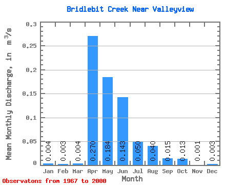
| Statistic | Jan | Feb | Mar | Apr | May | Jun | Jul | Aug | Sep | Oct | Nov | Dec | Annual |
|---|---|---|---|---|---|---|---|---|---|---|---|---|---|
| Mean | 0.00 | 0.00 | 0.00 | 0.27 | 0.18 | 0.14 | 0.05 | 0.04 | 0.01 | 0.01 | 0.00 | 0.00 | 0.04 |
| Standard Deviation | 0.00 | 0.00 | 0.00 | 0.23 | 0.18 | 0.20 | 0.09 | 0.12 | 0.04 | 0.02 | 0.00 | 0.00 | |
| Min | 0.00 | 0.00 | 0.00 | 0.00 | 0.00 | 0.00 | 0.00 | 0.00 | 0.00 | 0.00 | 0.00 | 0.00 | 0.04 |
| Max | 0.01 | 0.00 | 0.01 | 0.90 | 0.63 | 0.81 | 0.30 | 0.62 | 0.22 | 0.09 | 0.00 | 0.00 | 0.04 |
| Coefficient of Variation | 0.32 | 0.00 | 0.69 | 0.87 | 0.96 | 1.41 | 1.74 | 3.00 | 2.83 | 1.66 | 1.00 | 0.35 |
 Return to R-Arctic Net Home Page