|
|
|||||||||||||||||
| Point ID: 761 | Downloads | Plots | Site Data | Code: 07GF005 |
|
|
|||||||||||||||||
| Download | |
|---|---|
| Site Descriptor Information | Site Time Series Data |
| Link to all available data | |
| View: | Time Series | All |
| Units: | m3/s |
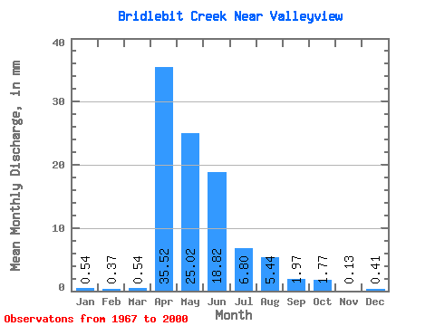
| Statistic | Jan | Feb | Mar | Apr | May | Jun | Jul | Aug | Sep | Oct | Nov | Dec | Annual |
|---|---|---|---|---|---|---|---|---|---|---|---|---|---|
| Mean | 0.50 | 0.37 | 0.51 | 35.51 | 24.95 | 18.85 | 6.78 | 5.47 | 1.94 | 1.79 | 0.13 | 0.45 | 57.94 |
| Standard Deviation | 0.16 | 0.00 | 0.35 | 30.82 | 23.98 | 26.58 | 11.80 | 16.43 | 5.49 | 2.97 | 0.13 | 0.16 | |
| Min | 0.41 | 0.37 | 0.00 | 0.40 | 0.14 | 0.00 | 0.00 | 0.00 | 0.00 | 0.00 | 0.00 | 0.27 | 57.94 |
| Max | 0.68 | 0.37 | 0.95 | 118.28 | 86.19 | 107.23 | 41.19 | 84.28 | 29.47 | 12.23 | 0.26 | 0.54 | 57.94 |
| Coefficient of Variation | 0.32 | 0.00 | 0.69 | 0.87 | 0.96 | 1.41 | 1.74 | 3.00 | 2.83 | 1.66 | 1.00 | 0.35 |
 Return to R-Arctic Net Home Page