|
|
|||||||||||||||||
| Point ID: 7609 | Downloads | Plots | Site Data | Code: 71134 |
|
|
|||||||||||||||||
| Download | |
|---|---|
| Site Descriptor Information | Site Time Series Data |
| Link to all available data | |
| View: | Time Series | All |
| Units: | mm |
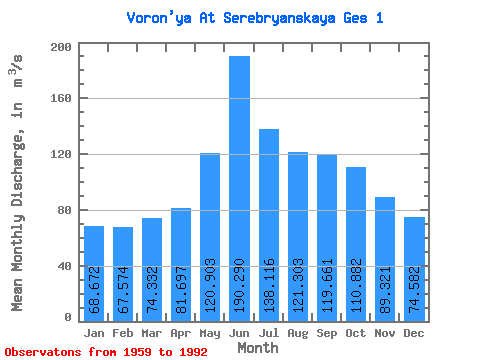
| Statistic | Jan | Feb | Mar | Apr | May | Jun | Jul | Aug | Sep | Oct | Nov | Dec | Annual |
|---|---|---|---|---|---|---|---|---|---|---|---|---|---|
| Mean | 68.67 | 67.57 | 74.33 | 81.70 | 120.90 | 190.29 | 138.12 | 121.30 | 119.66 | 110.88 | 89.32 | 74.58 | 105.04 |
| Standard Deviation | 36.92 | 41.61 | 42.06 | 51.19 | 106.50 | 135.88 | 59.72 | 42.78 | 40.04 | 40.95 | 33.51 | 33.38 | 20.06 |
| Min | 19.40 | 15.00 | 13.60 | 13.80 | 16.80 | 33.70 | 36.10 | 20.30 | 40.00 | 34.50 | 28.50 | 19.70 | 46.89 |
| Max | 153.00 | 160.00 | 155.00 | 202.00 | 462.00 | 548.00 | 290.00 | 210.00 | 188.00 | 187.00 | 168.00 | 153.00 | 143.78 |
| Coefficient of Variation | 0.54 | 0.62 | 0.57 | 0.63 | 0.88 | 0.71 | 0.43 | 0.35 | 0.34 | 0.37 | 0.38 | 0.45 | 0.19 |
 Return to R-Arctic Net Home Page