|
|
|||||||||||||||||
| Point ID: 7609 | Downloads | Plots | Site Data | Code: 71134 |
|
|
|||||||||||||||||
| Download | |
|---|---|
| Site Descriptor Information | Site Time Series Data |
| Link to all available data | |
| View: | Time Series | All |
| Units: | m3/s |
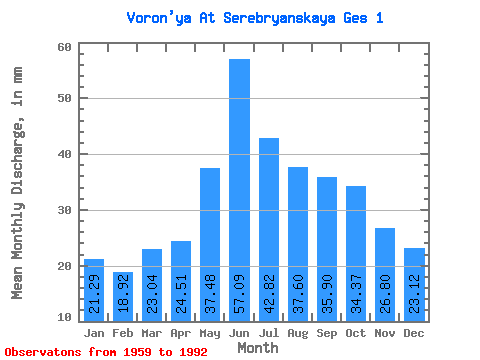
| Statistic | Jan | Feb | Mar | Apr | May | Jun | Jul | Aug | Sep | Oct | Nov | Dec | Annual |
|---|---|---|---|---|---|---|---|---|---|---|---|---|---|
| Mean | 21.29 | 19.08 | 23.04 | 24.51 | 37.47 | 57.09 | 42.81 | 37.60 | 35.90 | 34.37 | 26.80 | 23.12 | 383.69 |
| Standard Deviation | 11.44 | 11.75 | 13.04 | 15.36 | 33.01 | 40.76 | 18.51 | 13.26 | 12.01 | 12.69 | 10.05 | 10.35 | 73.28 |
| Min | 6.01 | 4.24 | 4.21 | 4.14 | 5.21 | 10.11 | 11.19 | 6.29 | 12.00 | 10.69 | 8.55 | 6.11 | 171.28 |
| Max | 47.42 | 45.19 | 48.04 | 60.60 | 143.20 | 164.40 | 89.89 | 65.09 | 56.40 | 57.96 | 50.40 | 47.42 | 525.21 |
| Coefficient of Variation | 0.54 | 0.62 | 0.57 | 0.63 | 0.88 | 0.71 | 0.43 | 0.35 | 0.34 | 0.37 | 0.38 | 0.45 | 0.19 |
 Return to R-Arctic Net Home Page