|
|
|||||||||||||||||
| Point ID: 7608 | Downloads | Plots | Site Data | Code: 71131 |
|
|
|||||||||||||||||
| Download | |
|---|---|
| Site Descriptor Information | Site Time Series Data |
| Link to all available data | |
| View: | Time Series | All |
| Units: | mm |
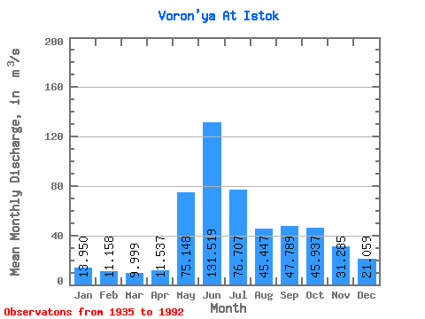
| Statistic | Jan | Feb | Mar | Apr | May | Jun | Jul | Aug | Sep | Oct | Nov | Dec | Annual |
|---|---|---|---|---|---|---|---|---|---|---|---|---|---|
| Mean | 13.95 | 11.16 | 10.00 | 11.54 | 75.15 | 131.52 | 76.71 | 45.45 | 47.79 | 45.94 | 31.29 | 21.06 | 43.00 |
| Standard Deviation | 3.24 | 2.31 | 2.08 | 5.06 | 41.96 | 40.08 | 28.35 | 21.97 | 18.37 | 18.48 | 12.86 | 7.31 | 9.74 |
| Min | 8.19 | 4.51 | 5.71 | 5.95 | 7.36 | 40.80 | 18.90 | 11.20 | 18.70 | 15.90 | 12.10 | 9.33 | 19.68 |
| Max | 21.20 | 15.70 | 14.60 | 29.20 | 167.00 | 217.00 | 140.00 | 130.00 | 78.60 | 85.00 | 70.50 | 39.80 | 66.99 |
| Coefficient of Variation | 0.23 | 0.21 | 0.21 | 0.44 | 0.56 | 0.30 | 0.37 | 0.48 | 0.38 | 0.40 | 0.41 | 0.35 | 0.23 |
 Return to R-Arctic Net Home Page