|
|
|||||||||||||||||
| Point ID: 7608 | Downloads | Plots | Site Data | Code: 71131 |
|
|
|||||||||||||||||
| Download | |
|---|---|
| Site Descriptor Information | Site Time Series Data |
| Link to all available data | |
| View: | Time Series | All |
| Units: | m3/s |
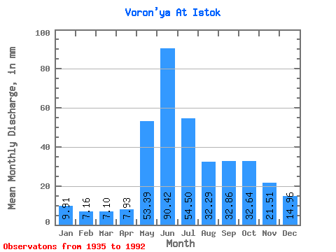
| Statistic | Jan | Feb | Mar | Apr | May | Jun | Jul | Aug | Sep | Oct | Nov | Dec | Annual |
|---|---|---|---|---|---|---|---|---|---|---|---|---|---|
| Mean | 9.91 | 7.22 | 7.10 | 7.93 | 53.38 | 90.42 | 54.49 | 32.28 | 32.86 | 32.63 | 21.51 | 14.96 | 359.98 |
| Standard Deviation | 2.30 | 1.50 | 1.48 | 3.48 | 29.81 | 27.56 | 20.14 | 15.60 | 12.63 | 13.13 | 8.84 | 5.19 | 81.55 |
| Min | 5.82 | 2.92 | 4.06 | 4.09 | 5.23 | 28.05 | 13.43 | 7.96 | 12.86 | 11.29 | 8.32 | 6.63 | 164.78 |
| Max | 15.06 | 10.16 | 10.37 | 20.08 | 118.63 | 149.19 | 99.45 | 92.34 | 54.04 | 60.38 | 48.47 | 28.27 | 560.81 |
| Coefficient of Variation | 0.23 | 0.21 | 0.21 | 0.44 | 0.56 | 0.30 | 0.37 | 0.48 | 0.38 | 0.40 | 0.41 | 0.35 | 0.23 |
 Return to R-Arctic Net Home Page