|
|
|||||||||||||||||
| Point ID: 7587 | Downloads | Plots | Site Data | Code: 71072 |
|
|
|||||||||||||||||
| Download | |
|---|---|
| Site Descriptor Information | Site Time Series Data |
| Link to all available data | |
| View: | Time Series | All |
| Units: | mm |
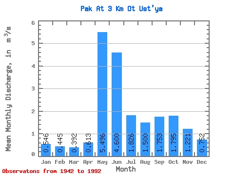
| Statistic | Jan | Feb | Mar | Apr | May | Jun | Jul | Aug | Sep | Oct | Nov | Dec | Annual |
|---|---|---|---|---|---|---|---|---|---|---|---|---|---|
| Mean | 0.55 | 0.45 | 0.39 | 0.61 | 5.50 | 4.60 | 1.83 | 1.50 | 1.75 | 1.79 | 1.22 | 0.75 | 1.77 |
| Standard Deviation | 0.14 | 0.14 | 0.12 | 0.50 | 2.77 | 2.45 | 1.02 | 0.77 | 0.79 | 0.65 | 0.51 | 0.19 | 0.41 |
| Min | 0.20 | 0.01 | 0.09 | 0.01 | 1.15 | 1.34 | 0.53 | 0.39 | 0.52 | 0.39 | 0.28 | 0.27 | 0.83 |
| Max | 0.90 | 0.88 | 0.67 | 2.28 | 12.80 | 10.80 | 5.78 | 3.84 | 5.05 | 3.39 | 3.47 | 1.23 | 2.70 |
| Coefficient of Variation | 0.26 | 0.32 | 0.32 | 0.81 | 0.51 | 0.53 | 0.56 | 0.51 | 0.45 | 0.36 | 0.41 | 0.25 | 0.23 |
 Return to R-Arctic Net Home Page