|
|
|||||||||||||||||
| Point ID: 7587 | Downloads | Plots | Site Data | Code: 71072 |
|
|
|||||||||||||||||
| Download | |
|---|---|
| Site Descriptor Information | Site Time Series Data |
| Link to all available data | |
| View: | Time Series | All |
| Units: | m3/s |
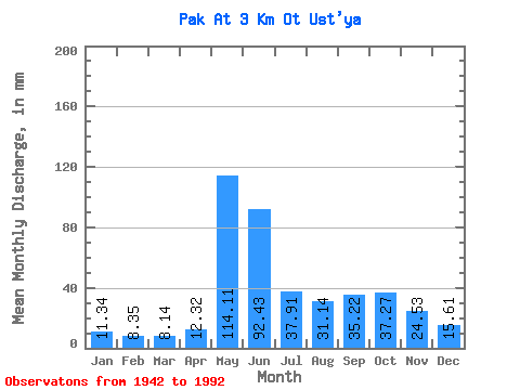
| Statistic | Jan | Feb | Mar | Apr | May | Jun | Jul | Aug | Sep | Oct | Nov | Dec | Annual |
|---|---|---|---|---|---|---|---|---|---|---|---|---|---|
| Mean | 11.33 | 8.42 | 8.13 | 12.32 | 114.10 | 92.43 | 37.91 | 31.15 | 35.22 | 37.26 | 24.54 | 15.62 | 431.82 |
| Standard Deviation | 2.99 | 2.73 | 2.58 | 9.96 | 57.59 | 49.18 | 21.08 | 15.95 | 15.93 | 13.46 | 10.15 | 3.91 | 99.28 |
| Min | 4.15 | 0.19 | 1.81 | 0.16 | 23.87 | 26.93 | 11.00 | 8.10 | 10.45 | 8.10 | 5.63 | 5.61 | 202.45 |
| Max | 18.68 | 16.64 | 13.91 | 45.81 | 265.72 | 217.00 | 119.99 | 79.72 | 101.47 | 70.38 | 69.72 | 25.53 | 660.35 |
| Coefficient of Variation | 0.26 | 0.32 | 0.32 | 0.81 | 0.51 | 0.53 | 0.56 | 0.51 | 0.45 | 0.36 | 0.41 | 0.25 | 0.23 |
 Return to R-Arctic Net Home Page