|
|
|||||||||||||||||
| Point ID: 7585 | Downloads | Plots | Site Data | Code: 71067 |
|
|
|||||||||||||||||
| Download | |
|---|---|
| Site Descriptor Information | Site Time Series Data |
| Link to all available data | |
| View: | Time Series | All |
| Units: | mm |
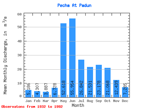
| Statistic | Jan | Feb | Mar | Apr | May | Jun | Jul | Aug | Sep | Oct | Nov | Dec | Annual |
|---|---|---|---|---|---|---|---|---|---|---|---|---|---|
| Mean | 5.19 | 4.31 | 3.89 | 6.73 | 52.62 | 55.95 | 26.84 | 21.53 | 23.18 | 21.07 | 12.44 | 7.29 | 20.09 |
| Standard Deviation | 1.16 | 1.00 | 0.91 | 5.71 | 21.50 | 21.59 | 13.46 | 12.53 | 10.79 | 8.36 | 5.20 | 1.93 | 4.36 |
| Min | 1.89 | 1.88 | 2.08 | 2.43 | 23.00 | 17.00 | 9.32 | 4.36 | 9.42 | 6.50 | 2.92 | 2.47 | 11.02 |
| Max | 7.80 | 7.30 | 7.00 | 28.50 | 110.00 | 110.00 | 66.50 | 61.40 | 55.70 | 40.60 | 33.10 | 13.20 | 32.67 |
| Coefficient of Variation | 0.22 | 0.23 | 0.23 | 0.85 | 0.41 | 0.39 | 0.50 | 0.58 | 0.47 | 0.40 | 0.42 | 0.27 | 0.22 |
 Return to R-Arctic Net Home Page