|
|
|||||||||||||||||
| Point ID: 7585 | Downloads | Plots | Site Data | Code: 71067 |
|
|
|||||||||||||||||
| Download | |
|---|---|
| Site Descriptor Information | Site Time Series Data |
| Link to all available data | |
| View: | Time Series | All |
| Units: | m3/s |
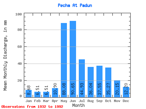
| Statistic | Jan | Feb | Mar | Apr | May | Jun | Jul | Aug | Sep | Oct | Nov | Dec | Annual |
|---|---|---|---|---|---|---|---|---|---|---|---|---|---|
| Mean | 8.68 | 6.57 | 6.50 | 10.90 | 88.07 | 90.65 | 44.93 | 36.04 | 37.55 | 35.26 | 20.15 | 12.19 | 396.18 |
| Standard Deviation | 1.94 | 1.53 | 1.52 | 9.25 | 35.98 | 34.98 | 22.52 | 20.96 | 17.48 | 13.99 | 8.42 | 3.24 | 86.03 |
| Min | 3.16 | 2.87 | 3.48 | 3.94 | 38.50 | 27.54 | 15.60 | 7.30 | 15.26 | 10.88 | 4.73 | 4.13 | 217.35 |
| Max | 13.05 | 11.13 | 11.72 | 46.17 | 184.11 | 178.20 | 111.30 | 102.77 | 90.23 | 67.95 | 53.62 | 22.09 | 644.42 |
| Coefficient of Variation | 0.22 | 0.23 | 0.23 | 0.85 | 0.41 | 0.39 | 0.50 | 0.58 | 0.47 | 0.40 | 0.42 | 0.27 | 0.22 |
 Return to R-Arctic Net Home Page