|
|
|||||||||||||||||
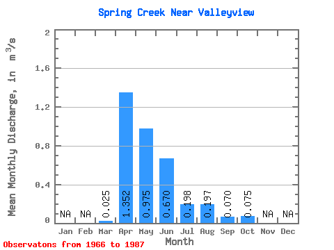
| Point ID: 758 | Downloads | Plots | Site Data | Code: 07GF002 |
|
|
|||||||||||||||||
| Download | |
|---|---|
| Site Descriptor Information | Site Time Series Data |
| Link to all available data | |
| View: | Time Series | All |
| Units: | mm |
| Statistic | Jan | Feb | Mar | Apr | May | Jun | Jul | Aug | Sep | Oct | Nov | Dec | Annual |
|---|---|---|---|---|---|---|---|---|---|---|---|---|---|
| Mean | 0.03 | 1.35 | 0.97 | 0.67 | 0.20 | 0.20 | 0.07 | 0.07 | |||||
| Standard Deviation | 0.04 | 1.19 | 0.88 | 0.80 | 0.35 | 0.59 | 0.08 | 0.10 | |||||
| Min | 0.00 | 0.11 | 0.11 | 0.03 | 0.00 | 0.00 | 0.00 | 0.00 | |||||
| Max | 0.11 | 4.47 | 2.91 | 2.65 | 1.25 | 2.67 | 0.30 | 0.36 | |||||
| Coefficient of Variation | 1.46 | 0.88 | 0.90 | 1.20 | 1.77 | 3.02 | 1.20 | 1.38 |
 Return to R-Arctic Net Home Page