|
|
|||||||||||||||||
| Point ID: 758 | Downloads | Plots | Site Data | Code: 07GF002 |
|
|
|||||||||||||||||
| Download | |
|---|---|
| Site Descriptor Information | Site Time Series Data |
| Link to all available data | |
| View: | Time Series | All |
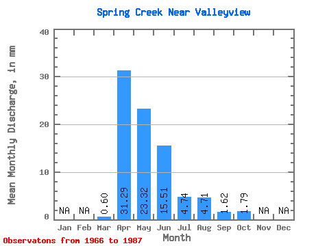
| Units: | m3/s |
| Statistic | Jan | Feb | Mar | Apr | May | Jun | Jul | Aug | Sep | Oct | Nov | Dec | Annual |
|---|---|---|---|---|---|---|---|---|---|---|---|---|---|
| Mean | 0.59 | 31.30 | 23.32 | 15.50 | 4.74 | 4.71 | 1.61 | 1.79 | |||||
| Standard Deviation | 0.87 | 27.63 | 20.99 | 18.52 | 8.38 | 14.22 | 1.94 | 2.48 | |||||
| Min | 0.00 | 2.55 | 2.70 | 0.67 | 0.07 | 0.00 | 0.00 | 0.00 | |||||
| Max | 2.58 | 103.45 | 69.58 | 61.33 | 29.89 | 63.84 | 6.85 | 8.73 | |||||
| Coefficient of Variation | 1.46 | 0.88 | 0.90 | 1.20 | 1.77 | 3.02 | 1.20 | 1.38 |
 Return to R-Arctic Net Home Page