|
|
|||||||||||||||||
| Point ID: 7572 | Downloads | Plots | Site Data | Code: 71010 |
|
|
|||||||||||||||||
| Download | |
|---|---|
| Site Descriptor Information | Site Time Series Data |
| Link to all available data | |
| View: | Time Series | All |
| Units: | mm |
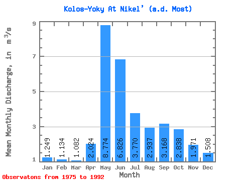
| Statistic | Jan | Feb | Mar | Apr | May | Jun | Jul | Aug | Sep | Oct | Nov | Dec | Annual |
|---|---|---|---|---|---|---|---|---|---|---|---|---|---|
| Mean | 1.25 | 1.13 | 1.08 | 2.02 | 8.77 | 6.83 | 3.77 | 2.94 | 3.17 | 2.84 | 1.97 | 1.51 | 3.06 |
| Standard Deviation | 0.33 | 0.32 | 0.28 | 1.35 | 2.72 | 3.43 | 2.15 | 1.07 | 1.19 | 0.75 | 0.42 | 0.33 | 0.68 |
| Min | 0.80 | 0.72 | 0.69 | 0.86 | 4.26 | 3.88 | 1.62 | 1.32 | 1.54 | 1.55 | 1.09 | 0.97 | 2.34 |
| Max | 1.84 | 1.80 | 1.55 | 4.76 | 13.20 | 17.30 | 8.05 | 5.48 | 6.92 | 4.19 | 2.77 | 2.17 | 4.48 |
| Coefficient of Variation | 0.26 | 0.28 | 0.26 | 0.67 | 0.31 | 0.50 | 0.57 | 0.36 | 0.38 | 0.26 | 0.22 | 0.22 | 0.22 |
 Return to R-Arctic Net Home Page