|
|
|||||||||||||||||
| Point ID: 7572 | Downloads | Plots | Site Data | Code: 71010 |
|
|
|||||||||||||||||
| Download | |
|---|---|
| Site Descriptor Information | Site Time Series Data |
| Link to all available data | |
| View: | Time Series | All |
| Units: | m3/s |
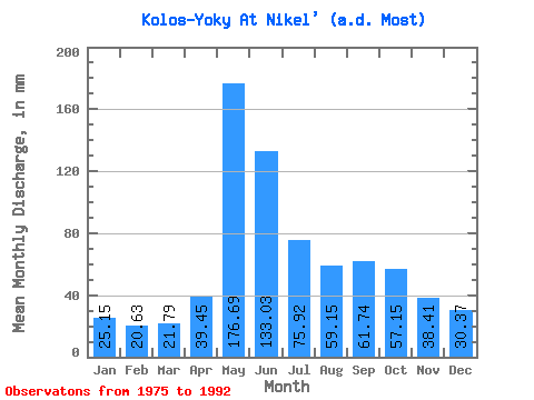
| Statistic | Jan | Feb | Mar | Apr | May | Jun | Jul | Aug | Sep | Oct | Nov | Dec | Annual |
|---|---|---|---|---|---|---|---|---|---|---|---|---|---|
| Mean | 25.16 | 20.81 | 21.78 | 39.44 | 176.66 | 133.03 | 75.91 | 59.13 | 61.75 | 57.14 | 38.41 | 30.37 | 726.62 |
| Standard Deviation | 6.58 | 5.86 | 5.62 | 26.25 | 54.75 | 66.87 | 43.35 | 21.53 | 23.24 | 15.02 | 8.29 | 6.69 | 162.03 |
| Min | 16.11 | 13.21 | 13.89 | 16.76 | 85.78 | 75.62 | 32.62 | 26.58 | 30.01 | 31.21 | 21.24 | 19.53 | 554.48 |
| Max | 37.05 | 33.02 | 31.21 | 92.77 | 265.79 | 337.15 | 162.09 | 110.34 | 134.86 | 84.37 | 53.98 | 43.69 | 1062.68 |
| Coefficient of Variation | 0.26 | 0.28 | 0.26 | 0.67 | 0.31 | 0.50 | 0.57 | 0.36 | 0.38 | 0.26 | 0.22 | 0.22 | 0.22 |
 Return to R-Arctic Net Home Page