|
|
|||||||||||||||||
| Point ID: 7521 | Downloads | Plots | Site Data | Code: 70533 |
|
|
|||||||||||||||||
| Download | |
|---|---|
| Site Descriptor Information | Site Time Series Data |
| Link to all available data | |
| View: | Time Series | All |
| Units: | mm |
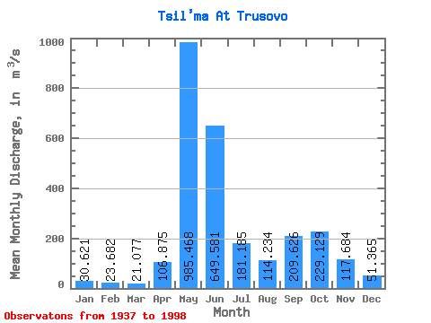
| Statistic | Jan | Feb | Mar | Apr | May | Jun | Jul | Aug | Sep | Oct | Nov | Dec | Annual |
|---|---|---|---|---|---|---|---|---|---|---|---|---|---|
| Mean | 30.62 | 23.68 | 21.08 | 106.88 | 985.47 | 649.58 | 181.19 | 114.23 | 209.63 | 229.13 | 117.68 | 51.37 | 227.75 |
| Standard Deviation | 10.12 | 6.45 | 5.01 | 199.77 | 377.90 | 433.66 | 110.94 | 78.67 | 109.97 | 107.01 | 68.55 | 21.76 | 36.71 |
| Min | 17.00 | 10.50 | 11.00 | 13.80 | 141.00 | 131.00 | 57.90 | 24.30 | 25.40 | 27.00 | 32.40 | 22.60 | 136.93 |
| Max | 60.80 | 45.80 | 32.90 | 912.00 | 1660.00 | 2330.00 | 571.00 | 356.00 | 443.00 | 528.00 | 476.00 | 123.00 | 298.45 |
| Coefficient of Variation | 0.33 | 0.27 | 0.24 | 1.87 | 0.38 | 0.67 | 0.61 | 0.69 | 0.53 | 0.47 | 0.58 | 0.42 | 0.16 |
 Return to R-Arctic Net Home Page