|
|
|||||||||||||||||
| Point ID: 7521 | Downloads | Plots | Site Data | Code: 70533 |
|
|
|||||||||||||||||
| Download | |
|---|---|
| Site Descriptor Information | Site Time Series Data |
| Link to all available data | |
| View: | Time Series | All |
| Units: | m3/s |
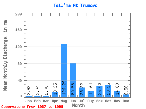
| Statistic | Jan | Feb | Mar | Apr | May | Jun | Jul | Aug | Sep | Oct | Nov | Dec | Annual |
|---|---|---|---|---|---|---|---|---|---|---|---|---|---|
| Mean | 3.92 | 2.77 | 2.70 | 13.26 | 126.27 | 80.56 | 23.22 | 14.64 | 26.00 | 29.36 | 14.60 | 6.58 | 343.91 |
| Standard Deviation | 1.30 | 0.75 | 0.64 | 24.77 | 48.42 | 53.78 | 14.21 | 10.08 | 13.64 | 13.71 | 8.50 | 2.79 | 55.43 |
| Min | 2.18 | 1.23 | 1.41 | 1.71 | 18.07 | 16.25 | 7.42 | 3.11 | 3.15 | 3.46 | 4.02 | 2.90 | 206.76 |
| Max | 7.79 | 5.35 | 4.22 | 113.11 | 212.70 | 288.96 | 73.16 | 45.62 | 54.94 | 67.66 | 59.03 | 15.76 | 450.67 |
| Coefficient of Variation | 0.33 | 0.27 | 0.24 | 1.87 | 0.38 | 0.67 | 0.61 | 0.69 | 0.53 | 0.47 | 0.58 | 0.42 | 0.16 |
 Return to R-Arctic Net Home Page