|
|
|||||||||||||||||
| Point ID: 7512 | Downloads | Plots | Site Data | Code: 70514 |
|
|
|||||||||||||||||
| Download | |
|---|---|
| Site Descriptor Information | Site Time Series Data |
| Link to all available data | |
| View: | Time Series | All |
| Units: | mm |
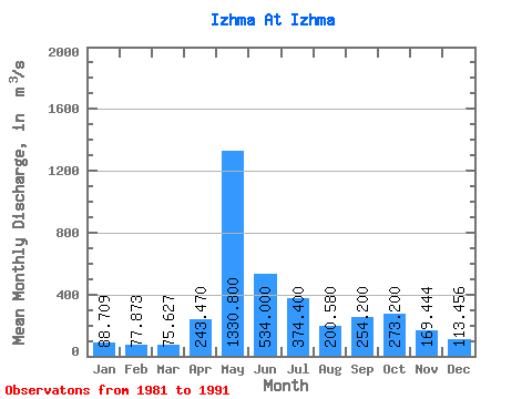
| Statistic | Jan | Feb | Mar | Apr | May | Jun | Jul | Aug | Sep | Oct | Nov | Dec | Annual |
|---|---|---|---|---|---|---|---|---|---|---|---|---|---|
| Mean | 88.71 | 77.87 | 75.63 | 243.47 | 1330.80 | 534.00 | 374.40 | 200.58 | 254.20 | 273.20 | 169.44 | 113.46 | 317.32 |
| Standard Deviation | 17.28 | 12.33 | 9.20 | 329.63 | 259.78 | 201.78 | 251.50 | 111.03 | 69.35 | 123.94 | 65.83 | 29.68 | 60.89 |
| Min | 71.40 | 64.70 | 67.00 | 73.60 | 858.00 | 217.00 | 121.00 | 91.40 | 101.00 | 162.00 | 106.00 | 85.80 | 197.07 |
| Max | 123.00 | 100.00 | 97.60 | 1080.00 | 1690.00 | 948.00 | 800.00 | 430.00 | 338.00 | 560.00 | 313.00 | 179.00 | 393.20 |
| Coefficient of Variation | 0.20 | 0.16 | 0.12 | 1.35 | 0.20 | 0.38 | 0.67 | 0.55 | 0.27 | 0.45 | 0.39 | 0.26 | 0.19 |
 Return to R-Arctic Net Home Page