|
|
|||||||||||||||||
| Point ID: 7512 | Downloads | Plots | Site Data | Code: 70514 |
|
|
|||||||||||||||||
| Download | |
|---|---|
| Site Descriptor Information | Site Time Series Data |
| Link to all available data | |
| View: | Time Series | All |
| Units: | m3/s |
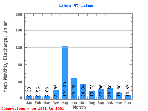
| Statistic | Jan | Feb | Mar | Apr | May | Jun | Jul | Aug | Sep | Oct | Nov | Dec | Annual |
|---|---|---|---|---|---|---|---|---|---|---|---|---|---|
| Mean | 8.28 | 6.62 | 7.06 | 21.99 | 124.18 | 48.23 | 34.94 | 18.72 | 22.96 | 25.49 | 15.30 | 10.59 | 348.95 |
| Standard Deviation | 1.61 | 1.05 | 0.86 | 29.77 | 24.24 | 18.22 | 23.47 | 10.36 | 6.26 | 11.56 | 5.95 | 2.77 | 66.96 |
| Min | 6.66 | 5.50 | 6.25 | 6.65 | 80.06 | 19.60 | 11.29 | 8.53 | 9.12 | 15.12 | 9.57 | 8.01 | 216.71 |
| Max | 11.48 | 8.50 | 9.11 | 97.54 | 157.69 | 85.62 | 74.65 | 40.12 | 30.53 | 52.25 | 28.27 | 16.70 | 432.38 |
| Coefficient of Variation | 0.20 | 0.16 | 0.12 | 1.35 | 0.20 | 0.38 | 0.67 | 0.55 | 0.27 | 0.45 | 0.39 | 0.26 | 0.19 |
 Return to R-Arctic Net Home Page