|
|
|||||||||||||||||
| Point ID: 7498 | Downloads | Plots | Site Data | Other Close Sites | Code: 70468 |
|
|
|||||||||||||||||
| Download | |
|---|---|
| Site Descriptor Information | Site Time Series Data |
| Link to all available data | |
| View: | Time Series | All |
| Units: | mm |
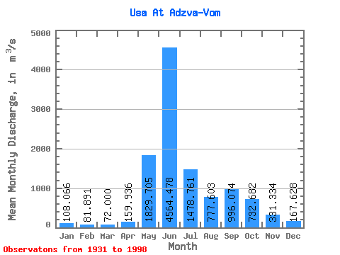
| Statistic | Jan | Feb | Mar | Apr | May | Jun | Jul | Aug | Sep | Oct | Nov | Dec | Annual |
|---|---|---|---|---|---|---|---|---|---|---|---|---|---|
| Mean | 108.07 | 81.89 | 72.00 | 159.94 | 1829.70 | 4564.48 | 1478.76 | 777.60 | 996.07 | 732.68 | 331.33 | 167.63 | 942.25 |
| Standard Deviation | 41.97 | 29.86 | 25.76 | 280.36 | 1354.10 | 1586.30 | 700.45 | 341.51 | 427.55 | 362.14 | 192.59 | 69.85 | 145.87 |
| Min | 54.00 | 45.20 | 36.80 | 35.50 | 66.30 | 1330.00 | 625.00 | 280.00 | 301.00 | 194.00 | 96.70 | 70.80 | 683.98 |
| Max | 310.00 | 226.00 | 191.00 | 1990.00 | 5640.00 | 7900.00 | 4270.00 | 1980.00 | 2260.00 | 1750.00 | 1160.00 | 468.00 | 1367.02 |
| Coefficient of Variation | 0.39 | 0.36 | 0.36 | 1.75 | 0.74 | 0.35 | 0.47 | 0.44 | 0.43 | 0.49 | 0.58 | 0.42 | 0.15 |
| Other Close Sites | ||||||
|---|---|---|---|---|---|---|
| PointID | Latitude | Longitude | Drainage Area | Source | Name | |
| 7503 | "Adzva At Salyukuvom" | 66.70 | -1317547 | SHI | 25.00 | |
 Return to R-Arctic Net Home Page