|
|
|||||||||||||||||
| Point ID: 7498 | Downloads | Plots | Site Data | Other Close Sites | Code: 70468 |
|
|
|||||||||||||||||
| Download | |
|---|---|
| Site Descriptor Information | Site Time Series Data |
| Link to all available data | |
| View: | Time Series | All |
| Units: | m3/s |
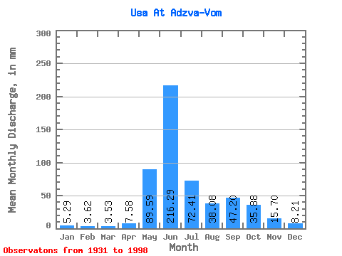
| Statistic | Jan | Feb | Mar | Apr | May | Jun | Jul | Aug | Sep | Oct | Nov | Dec | Annual |
|---|---|---|---|---|---|---|---|---|---|---|---|---|---|
| Mean | 5.29 | 3.65 | 3.52 | 7.58 | 89.58 | 216.29 | 72.40 | 38.07 | 47.20 | 35.87 | 15.70 | 8.21 | 543.64 |
| Standard Deviation | 2.06 | 1.33 | 1.26 | 13.29 | 66.29 | 75.17 | 34.29 | 16.72 | 20.26 | 17.73 | 9.13 | 3.42 | 84.16 |
| Min | 2.64 | 2.02 | 1.80 | 1.68 | 3.25 | 63.02 | 30.60 | 13.71 | 14.26 | 9.50 | 4.58 | 3.47 | 394.63 |
| Max | 15.18 | 10.08 | 9.35 | 94.30 | 276.12 | 374.35 | 209.05 | 96.94 | 107.09 | 85.68 | 54.97 | 22.91 | 788.72 |
| Coefficient of Variation | 0.39 | 0.36 | 0.36 | 1.75 | 0.74 | 0.35 | 0.47 | 0.44 | 0.43 | 0.49 | 0.58 | 0.42 | 0.15 |
| Other Close Sites | ||||||
|---|---|---|---|---|---|---|
| PointID | Latitude | Longitude | Drainage Area | Source | Name | |
| 7503 | "Adzva At Salyukuvom" | 66.70 | -1317547 | SHI | 25.00 | |
 Return to R-Arctic Net Home Page