|
|
|||||||||||||||||
| Point ID: 7497 | Downloads | Plots | Site Data | Code: 70466 |
|
|
|||||||||||||||||
| Download | |
|---|---|
| Site Descriptor Information | Site Time Series Data |
| Link to all available data | |
| View: | Time Series | All |
| Units: | mm |
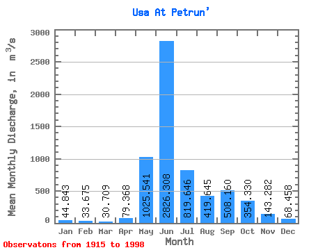
| Statistic | Jan | Feb | Mar | Apr | May | Jun | Jul | Aug | Sep | Oct | Nov | Dec | Annual |
|---|---|---|---|---|---|---|---|---|---|---|---|---|---|
| Mean | 44.84 | 33.67 | 30.71 | 79.37 | 1025.54 | 2826.31 | 819.65 | 419.64 | 508.16 | 354.33 | 143.28 | 68.46 | 525.43 |
| Standard Deviation | 22.86 | 15.93 | 13.65 | 165.97 | 900.60 | 1121.25 | 468.34 | 236.92 | 245.19 | 187.31 | 84.83 | 30.24 | 92.40 |
| Min | 7.25 | 9.07 | 10.80 | 11.20 | 22.30 | 769.00 | 151.00 | 86.60 | 130.00 | 72.60 | 38.80 | 14.50 | 325.32 |
| Max | 161.00 | 87.20 | 77.70 | 1240.00 | 3830.00 | 6600.00 | 2700.00 | 1590.00 | 1240.00 | 981.00 | 527.00 | 182.00 | 821.30 |
| Coefficient of Variation | 0.51 | 0.47 | 0.45 | 2.09 | 0.88 | 0.40 | 0.57 | 0.56 | 0.48 | 0.53 | 0.59 | 0.44 | 0.18 |
 Return to R-Arctic Net Home Page