|
|
|||||||||||||||||
| Point ID: 7497 | Downloads | Plots | Site Data | Code: 70466 |
|
|
|||||||||||||||||
| Download | |
|---|---|
| Site Descriptor Information | Site Time Series Data |
| Link to all available data | |
| View: | Time Series | All |
| Units: | m3/s |
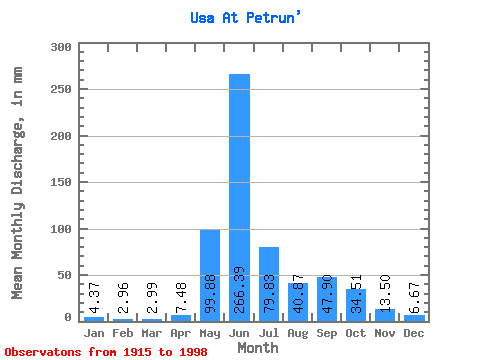
| Statistic | Jan | Feb | Mar | Apr | May | Jun | Jul | Aug | Sep | Oct | Nov | Dec | Annual |
|---|---|---|---|---|---|---|---|---|---|---|---|---|---|
| Mean | 4.37 | 2.99 | 2.99 | 7.48 | 99.87 | 266.39 | 79.82 | 40.87 | 47.90 | 34.51 | 13.51 | 6.67 | 603.01 |
| Standard Deviation | 2.23 | 1.41 | 1.33 | 15.64 | 87.70 | 105.68 | 45.61 | 23.07 | 23.11 | 18.24 | 8.00 | 2.94 | 106.05 |
| Min | 0.71 | 0.81 | 1.05 | 1.06 | 2.17 | 72.48 | 14.71 | 8.43 | 12.25 | 7.07 | 3.66 | 1.41 | 373.36 |
| Max | 15.68 | 7.74 | 7.57 | 116.88 | 372.97 | 622.08 | 262.93 | 154.84 | 116.88 | 95.53 | 49.67 | 17.72 | 942.55 |
| Coefficient of Variation | 0.51 | 0.47 | 0.45 | 2.09 | 0.88 | 0.40 | 0.57 | 0.56 | 0.48 | 0.53 | 0.59 | 0.44 | 0.18 |
 Return to R-Arctic Net Home Page