|
|
|||||||||||||||||
| Point ID: 7495 | Downloads | Plots | Site Data | Code: 70459 |
|
|
|||||||||||||||||
| Download | |
|---|---|
| Site Descriptor Information | Site Time Series Data |
| Link to all available data | |
| View: | Time Series | All |
| Units: | mm |
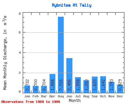
| Statistic | Jan | Feb | Mar | Apr | May | Jun | Jul | Aug | Sep | Oct | Nov | Dec | Annual |
|---|---|---|---|---|---|---|---|---|---|---|---|---|---|
| Mean | 0.73 | 0.70 | 0.70 | 1.87 | 7.56 | 3.46 | 1.56 | 1.26 | 1.62 | 1.64 | 1.09 | 0.83 | 1.92 |
| Standard Deviation | 0.14 | 0.13 | 0.11 | 1.85 | 2.06 | 2.27 | 0.65 | 0.39 | 0.65 | 0.58 | 0.27 | 0.14 | 0.25 |
| Min | 0.54 | 0.47 | 0.45 | 0.63 | 3.12 | 1.45 | 0.75 | 0.64 | 0.77 | 0.92 | 0.67 | 0.56 | 1.52 |
| Max | 1.00 | 1.02 | 0.91 | 8.11 | 11.10 | 10.80 | 3.71 | 2.57 | 3.99 | 3.52 | 1.88 | 1.09 | 2.47 |
| Coefficient of Variation | 0.19 | 0.19 | 0.16 | 0.99 | 0.27 | 0.66 | 0.42 | 0.31 | 0.40 | 0.35 | 0.25 | 0.17 | 0.13 |
 Return to R-Arctic Net Home Page