|
|
|||||||||||||||||
| Point ID: 7495 | Downloads | Plots | Site Data | Code: 70459 |
|
|
|||||||||||||||||
| Download | |
|---|---|
| Site Descriptor Information | Site Time Series Data |
| Link to all available data | |
| View: | Time Series | All |
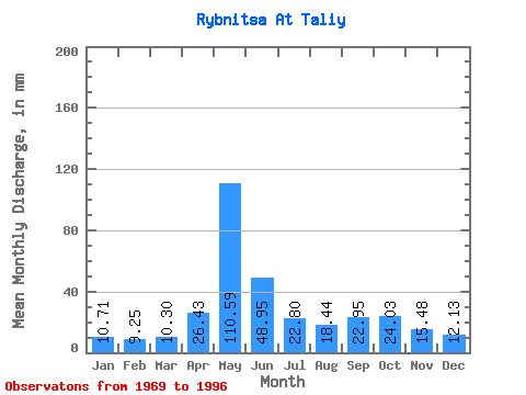
| Units: | m3/s |
| Statistic | Jan | Feb | Mar | Apr | May | Jun | Jul | Aug | Sep | Oct | Nov | Dec | Annual |
|---|---|---|---|---|---|---|---|---|---|---|---|---|---|
| Mean | 10.71 | 9.34 | 10.31 | 26.44 | 110.58 | 48.95 | 22.80 | 18.45 | 22.95 | 24.02 | 15.48 | 12.13 | 330.61 |
| Standard Deviation | 2.06 | 1.76 | 1.66 | 26.22 | 30.16 | 32.15 | 9.52 | 5.75 | 9.23 | 8.48 | 3.85 | 2.13 | 42.49 |
| Min | 7.90 | 6.27 | 6.58 | 8.92 | 45.66 | 20.54 | 10.97 | 9.37 | 10.91 | 13.46 | 9.49 | 8.20 | 261.85 |
| Max | 14.63 | 13.60 | 13.32 | 114.87 | 162.44 | 152.97 | 54.29 | 37.61 | 56.51 | 51.51 | 26.63 | 15.95 | 425.40 |
| Coefficient of Variation | 0.19 | 0.19 | 0.16 | 0.99 | 0.27 | 0.66 | 0.42 | 0.31 | 0.40 | 0.35 | 0.25 | 0.17 | 0.13 |
 Return to R-Arctic Net Home Page