|
|
|||||||||||||||||
| Point ID: 7482 | Downloads | Plots | Site Data | Code: 70414 |
|
|
|||||||||||||||||
| Download | |
|---|---|
| Site Descriptor Information | Site Time Series Data |
| Link to all available data | |
| View: | Time Series | All |
| Units: | mm |
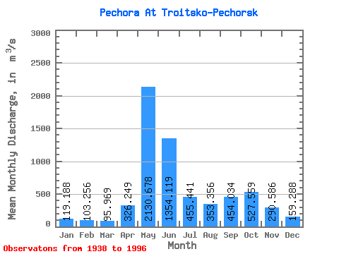
| Statistic | Jan | Feb | Mar | Apr | May | Jun | Jul | Aug | Sep | Oct | Nov | Dec | Annual |
|---|---|---|---|---|---|---|---|---|---|---|---|---|---|
| Mean | 119.19 | 103.26 | 95.97 | 326.25 | 2130.68 | 1354.12 | 455.44 | 353.36 | 454.03 | 527.56 | 290.59 | 159.29 | 530.30 |
| Standard Deviation | 24.82 | 21.10 | 19.96 | 362.27 | 523.43 | 626.91 | 217.65 | 217.92 | 213.56 | 219.42 | 140.08 | 41.71 | 79.81 |
| Min | 78.70 | 65.70 | 49.80 | 64.00 | 1050.00 | 370.00 | 185.00 | 124.00 | 150.00 | 139.00 | 107.00 | 64.20 | 271.49 |
| Max | 204.00 | 173.00 | 151.00 | 1830.00 | 3140.00 | 2690.00 | 1180.00 | 1040.00 | 945.00 | 1240.00 | 728.00 | 300.00 | 700.00 |
| Coefficient of Variation | 0.21 | 0.20 | 0.21 | 1.11 | 0.25 | 0.46 | 0.48 | 0.62 | 0.47 | 0.42 | 0.48 | 0.26 | 0.15 |
 Return to R-Arctic Net Home Page