|
|
|||||||||||||||||
| Point ID: 7482 | Downloads | Plots | Site Data | Code: 70414 |
|
|
|||||||||||||||||
| Download | |
|---|---|
| Site Descriptor Information | Site Time Series Data |
| Link to all available data | |
| View: | Time Series | All |
| Units: | m3/s |
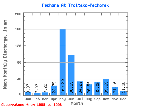
| Statistic | Jan | Feb | Mar | Apr | May | Jun | Jul | Aug | Sep | Oct | Nov | Dec | Annual |
|---|---|---|---|---|---|---|---|---|---|---|---|---|---|
| Mean | 8.97 | 7.08 | 7.22 | 23.75 | 160.28 | 98.59 | 34.26 | 26.58 | 33.06 | 39.69 | 21.16 | 11.98 | 470.12 |
| Standard Deviation | 1.87 | 1.45 | 1.50 | 26.38 | 39.38 | 45.65 | 16.37 | 16.39 | 15.55 | 16.51 | 10.20 | 3.14 | 70.75 |
| Min | 5.92 | 4.50 | 3.75 | 4.66 | 78.99 | 26.94 | 13.92 | 9.33 | 10.92 | 10.46 | 7.79 | 4.83 | 240.68 |
| Max | 15.35 | 11.86 | 11.36 | 133.24 | 236.21 | 195.86 | 88.77 | 78.23 | 68.80 | 93.28 | 53.01 | 22.57 | 620.56 |
| Coefficient of Variation | 0.21 | 0.20 | 0.21 | 1.11 | 0.25 | 0.46 | 0.48 | 0.62 | 0.47 | 0.42 | 0.48 | 0.26 | 0.15 |
 Return to R-Arctic Net Home Page