|
|
|||||||||||||||||
| Point ID: 7475 | Downloads | Plots | Site Data | Code: 70397 |
|
|
|||||||||||||||||
| Download | |
|---|---|
| Site Descriptor Information | Site Time Series Data |
| Link to all available data | |
| View: | Time Series | All |
| Units: | mm |
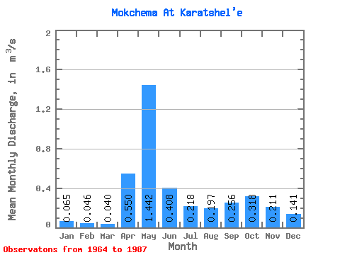
| Statistic | Jan | Feb | Mar | Apr | May | Jun | Jul | Aug | Sep | Oct | Nov | Dec | Annual |
|---|---|---|---|---|---|---|---|---|---|---|---|---|---|
| Mean | 0.07 | 0.05 | 0.04 | 0.55 | 1.44 | 0.41 | 0.22 | 0.20 | 0.26 | 0.32 | 0.21 | 0.14 | 0.33 |
| Standard Deviation | 0.02 | 0.01 | 0.01 | 0.59 | 0.54 | 0.22 | 0.14 | 0.16 | 0.16 | 0.17 | 0.10 | 0.18 | 0.07 |
| Min | 0.03 | 0.01 | 0.02 | 0.03 | 0.44 | 0.17 | 0.09 | 0.07 | 0.07 | 0.07 | 0.07 | 0.02 | 0.19 |
| Max | 0.12 | 0.07 | 0.06 | 2.10 | 2.46 | 0.88 | 0.72 | 0.83 | 0.66 | 0.74 | 0.38 | 0.91 | 0.48 |
| Coefficient of Variation | 0.36 | 0.27 | 0.27 | 1.07 | 0.38 | 0.55 | 0.66 | 0.82 | 0.62 | 0.54 | 0.48 | 1.27 | 0.21 |
 Return to R-Arctic Net Home Page