|
|
|||||||||||||||||
| Point ID: 7475 | Downloads | Plots | Site Data | Code: 70397 |
|
|
|||||||||||||||||
| Download | |
|---|---|
| Site Descriptor Information | Site Time Series Data |
| Link to all available data | |
| View: | Time Series | All |
| Units: | m3/s |
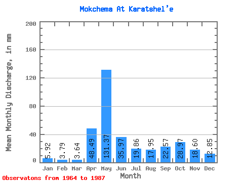
| Statistic | Jan | Feb | Mar | Apr | May | Jun | Jul | Aug | Sep | Oct | Nov | Dec | Annual |
|---|---|---|---|---|---|---|---|---|---|---|---|---|---|
| Mean | 5.93 | 3.80 | 3.68 | 48.47 | 131.37 | 35.96 | 19.89 | 17.96 | 22.61 | 28.97 | 18.62 | 12.82 | 348.50 |
| Standard Deviation | 2.15 | 1.02 | 0.99 | 51.92 | 49.34 | 19.78 | 13.21 | 14.69 | 14.03 | 15.75 | 9.04 | 16.23 | 73.37 |
| Min | 2.92 | 1.25 | 1.64 | 2.82 | 40.08 | 14.99 | 8.20 | 6.56 | 5.73 | 6.29 | 5.73 | 2.00 | 203.51 |
| Max | 10.93 | 6.22 | 5.74 | 185.14 | 224.08 | 77.58 | 65.58 | 75.60 | 58.19 | 67.41 | 33.50 | 82.89 | 516.34 |
| Coefficient of Variation | 0.36 | 0.27 | 0.27 | 1.07 | 0.38 | 0.55 | 0.66 | 0.82 | 0.62 | 0.54 | 0.48 | 1.27 | 0.21 |
 Return to R-Arctic Net Home Page