|
|
|||||||||||||||||
| Point ID: 7472 | Downloads | Plots | Site Data | Code: 70393 |
|
|
|||||||||||||||||
| Download | |
|---|---|
| Site Descriptor Information | Site Time Series Data |
| Link to all available data | |
| View: | Time Series | All |
| Units: | mm |
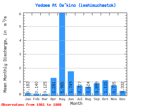
| Statistic | Jan | Feb | Mar | Apr | May | Jun | Jul | Aug | Sep | Oct | Nov | Dec | Annual |
|---|---|---|---|---|---|---|---|---|---|---|---|---|---|
| Mean | 0.18 | 0.14 | 0.12 | 1.28 | 5.99 | 1.75 | 0.73 | 0.62 | 0.90 | 1.11 | 0.73 | 0.33 | 1.18 |
| Standard Deviation | 0.05 | 0.05 | 0.04 | 1.82 | 2.20 | 1.09 | 0.48 | 0.52 | 0.68 | 0.69 | 0.37 | 0.18 | 0.28 |
| Min | 0.10 | 0.05 | 0.06 | 0.09 | 1.98 | 0.37 | 0.22 | 0.20 | 0.19 | 0.21 | 0.15 | 0.02 | 0.60 |
| Max | 0.33 | 0.23 | 0.23 | 7.71 | 9.85 | 4.45 | 2.13 | 2.73 | 2.93 | 3.71 | 1.47 | 0.83 | 1.76 |
| Coefficient of Variation | 0.29 | 0.34 | 0.33 | 1.42 | 0.37 | 0.63 | 0.66 | 0.83 | 0.76 | 0.62 | 0.50 | 0.54 | 0.24 |
 Return to R-Arctic Net Home Page