|
|
|||||||||||||||||
| Point ID: 7472 | Downloads | Plots | Site Data | Code: 70393 |
|
|
|||||||||||||||||
| Download | |
|---|---|
| Site Descriptor Information | Site Time Series Data |
| Link to all available data | |
| View: | Time Series | All |
| Units: | m3/s |
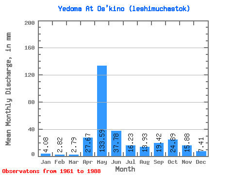
| Statistic | Jan | Feb | Mar | Apr | May | Jun | Jul | Aug | Sep | Oct | Nov | Dec | Annual |
|---|---|---|---|---|---|---|---|---|---|---|---|---|---|
| Mean | 4.08 | 2.84 | 2.79 | 27.66 | 133.56 | 37.78 | 16.23 | 13.94 | 19.43 | 24.88 | 15.88 | 7.42 | 308.93 |
| Standard Deviation | 1.20 | 0.97 | 0.93 | 39.29 | 49.06 | 23.66 | 10.73 | 11.60 | 14.74 | 15.46 | 7.94 | 4.00 | 73.71 |
| Min | 2.23 | 1.10 | 1.25 | 1.86 | 44.19 | 7.99 | 4.91 | 4.46 | 4.10 | 4.69 | 3.24 | 0.45 | 158.09 |
| Max | 7.37 | 4.68 | 5.13 | 166.54 | 219.82 | 96.12 | 47.53 | 60.92 | 63.29 | 82.80 | 31.75 | 18.52 | 463.54 |
| Coefficient of Variation | 0.29 | 0.34 | 0.33 | 1.42 | 0.37 | 0.63 | 0.66 | 0.83 | 0.76 | 0.62 | 0.50 | 0.54 | 0.24 |
 Return to R-Arctic Net Home Page