|
|
|||||||||||||||||
| Point ID: 7461 | Downloads | Plots | Site Data | Code: 70364 |
|
|
|||||||||||||||||
| Download | |
|---|---|
| Site Descriptor Information | Site Time Series Data |
| Link to all available data | |
| View: | Time Series | All |
| Units: | mm |
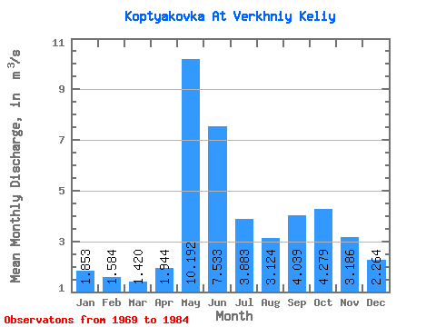
| Statistic | Jan | Feb | Mar | Apr | May | Jun | Jul | Aug | Sep | Oct | Nov | Dec | Annual |
|---|---|---|---|---|---|---|---|---|---|---|---|---|---|
| Mean | 1.85 | 1.58 | 1.42 | 1.94 | 10.19 | 7.53 | 3.88 | 3.12 | 4.04 | 4.28 | 3.19 | 2.26 | 3.74 |
| Standard Deviation | 0.29 | 0.22 | 0.18 | 1.52 | 3.69 | 3.97 | 1.77 | 1.23 | 1.63 | 1.56 | 0.91 | 0.51 | 0.68 |
| Min | 1.28 | 1.22 | 1.11 | 1.00 | 4.07 | 2.86 | 1.78 | 1.61 | 1.50 | 1.62 | 1.62 | 1.38 | 2.49 |
| Max | 2.23 | 1.88 | 1.67 | 7.20 | 16.90 | 15.10 | 8.61 | 5.19 | 6.78 | 7.05 | 4.37 | 3.02 | 4.44 |
| Coefficient of Variation | 0.16 | 0.14 | 0.13 | 0.78 | 0.36 | 0.53 | 0.46 | 0.39 | 0.40 | 0.36 | 0.28 | 0.23 | 0.18 |
 Return to R-Arctic Net Home Page