|
|
|||||||||||||||||
| Point ID: 7461 | Downloads | Plots | Site Data | Code: 70364 |
|
|
|||||||||||||||||
| Download | |
|---|---|
| Site Descriptor Information | Site Time Series Data |
| Link to all available data | |
| View: | Time Series | All |
| Units: | m3/s |
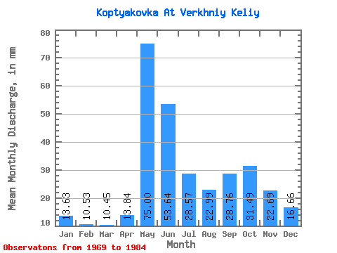
| Statistic | Jan | Feb | Mar | Apr | May | Jun | Jul | Aug | Sep | Oct | Nov | Dec | Annual |
|---|---|---|---|---|---|---|---|---|---|---|---|---|---|
| Mean | 13.63 | 10.62 | 10.45 | 13.84 | 74.98 | 53.64 | 28.57 | 22.98 | 28.76 | 31.48 | 22.69 | 16.66 | 323.89 |
| Standard Deviation | 2.15 | 1.47 | 1.33 | 10.81 | 27.13 | 28.27 | 13.02 | 9.01 | 11.60 | 11.48 | 6.46 | 3.75 | 59.14 |
| Min | 9.42 | 8.18 | 8.17 | 7.12 | 29.94 | 20.37 | 13.10 | 11.85 | 10.68 | 11.92 | 11.54 | 10.15 | 216.11 |
| Max | 16.41 | 12.60 | 12.29 | 51.27 | 124.34 | 107.53 | 63.34 | 38.18 | 48.28 | 51.87 | 31.12 | 22.22 | 385.04 |
| Coefficient of Variation | 0.16 | 0.14 | 0.13 | 0.78 | 0.36 | 0.53 | 0.46 | 0.39 | 0.40 | 0.36 | 0.28 | 0.23 | 0.18 |
 Return to R-Arctic Net Home Page