|
|
|||||||||||||||||
| Point ID: 7458 | Downloads | Plots | Site Data | Code: 70361 |
|
|
|||||||||||||||||
| Download | |
|---|---|
| Site Descriptor Information | Site Time Series Data |
| Link to all available data | |
| View: | Time Series | All |
| Units: | mm |
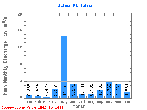
| Statistic | Jan | Feb | Mar | Apr | May | Jun | Jul | Aug | Sep | Oct | Nov | Dec | Annual |
|---|---|---|---|---|---|---|---|---|---|---|---|---|---|
| Mean | 0.84 | 0.52 | 0.43 | 2.26 | 14.59 | 3.27 | 1.13 | 0.99 | 1.91 | 3.76 | 3.27 | 1.53 | 2.81 |
| Standard Deviation | 0.46 | 0.32 | 0.21 | 2.98 | 3.67 | 2.13 | 0.84 | 1.16 | 1.80 | 2.15 | 2.55 | 1.05 | 0.66 |
| Min | 0.21 | 0.12 | 0.10 | 0.19 | 7.09 | 0.94 | 0.36 | 0.17 | 0.18 | 0.33 | 0.41 | 0.27 | 1.75 |
| Max | 1.88 | 1.47 | 1.03 | 13.80 | 24.80 | 8.78 | 3.08 | 5.34 | 7.09 | 9.03 | 10.70 | 3.86 | 4.27 |
| Coefficient of Variation | 0.55 | 0.61 | 0.50 | 1.32 | 0.25 | 0.65 | 0.74 | 1.17 | 0.95 | 0.57 | 0.78 | 0.69 | 0.23 |
 Return to R-Arctic Net Home Page