|
|
|||||||||||||||||
| Point ID: 7458 | Downloads | Plots | Site Data | Code: 70361 |
|
|
|||||||||||||||||
| Download | |
|---|---|
| Site Descriptor Information | Site Time Series Data |
| Link to all available data | |
| View: | Time Series | All |
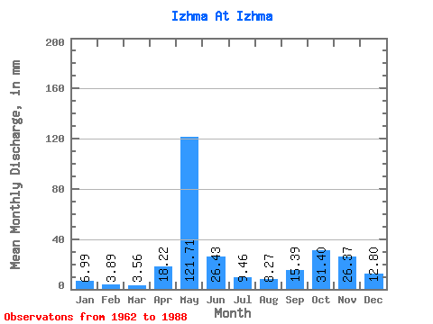
| Units: | m3/s |
| Statistic | Jan | Feb | Mar | Apr | May | Jun | Jul | Aug | Sep | Oct | Nov | Dec | Annual |
|---|---|---|---|---|---|---|---|---|---|---|---|---|---|
| Mean | 7.00 | 3.92 | 3.57 | 18.21 | 121.70 | 26.43 | 9.46 | 8.27 | 15.39 | 31.39 | 26.37 | 12.80 | 276.02 |
| Standard Deviation | 3.85 | 2.39 | 1.78 | 24.11 | 30.65 | 17.18 | 7.01 | 9.66 | 14.57 | 17.91 | 20.62 | 8.77 | 64.86 |
| Min | 1.75 | 0.91 | 0.79 | 1.53 | 59.15 | 7.59 | 3.00 | 1.42 | 1.45 | 2.75 | 3.31 | 2.25 | 171.65 |
| Max | 15.68 | 11.17 | 8.59 | 111.43 | 206.90 | 70.90 | 25.70 | 44.55 | 57.25 | 75.33 | 86.40 | 32.20 | 419.65 |
| Coefficient of Variation | 0.55 | 0.61 | 0.50 | 1.32 | 0.25 | 0.65 | 0.74 | 1.17 | 0.95 | 0.57 | 0.78 | 0.69 | 0.23 |
 Return to R-Arctic Net Home Page