|
|
|||||||||||||||||
| Point ID: 7430 | Downloads | Plots | Site Data | Code: 70298 |
|
|
|||||||||||||||||
| Download | |
|---|---|
| Site Descriptor Information | Site Time Series Data |
| Link to all available data | |
| View: | Time Series | All |
| Units: | mm |
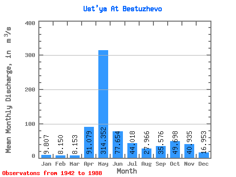
| Statistic | Jan | Feb | Mar | Apr | May | Jun | Jul | Aug | Sep | Oct | Nov | Dec | Annual |
|---|---|---|---|---|---|---|---|---|---|---|---|---|---|
| Mean | 9.81 | 8.15 | 8.15 | 91.08 | 314.35 | 77.65 | 44.02 | 27.97 | 35.58 | 49.70 | 40.94 | 16.95 | 60.34 |
| Standard Deviation | 3.44 | 1.99 | 1.50 | 85.32 | 132.66 | 41.64 | 37.59 | 33.26 | 41.91 | 37.76 | 29.71 | 12.14 | 15.18 |
| Min | 4.23 | 3.82 | 3.70 | 8.28 | 72.30 | 16.00 | 7.94 | 4.56 | 7.76 | 6.85 | 6.45 | 4.23 | 30.59 |
| Max | 19.70 | 13.70 | 13.50 | 330.00 | 563.00 | 251.00 | 162.00 | 210.00 | 261.00 | 203.00 | 142.00 | 65.30 | 108.28 |
| Coefficient of Variation | 0.35 | 0.24 | 0.18 | 0.94 | 0.42 | 0.54 | 0.85 | 1.19 | 1.18 | 0.76 | 0.73 | 0.72 | 0.25 |
 Return to R-Arctic Net Home Page