|
|
|||||||||||||||||
| Point ID: 7430 | Downloads | Plots | Site Data | Code: 70298 |
|
|
|||||||||||||||||
| Download | |
|---|---|
| Site Descriptor Information | Site Time Series Data |
| Link to all available data | |
| View: | Time Series | All |
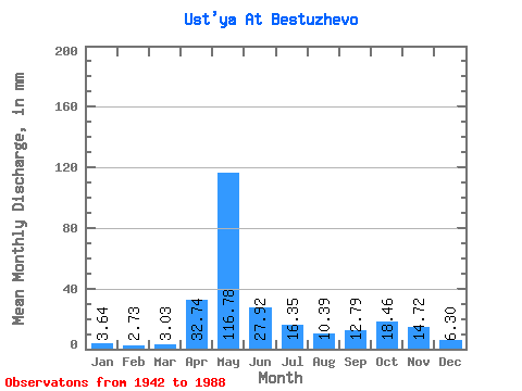
| Units: | m3/s |
| Statistic | Jan | Feb | Mar | Apr | May | Jun | Jul | Aug | Sep | Oct | Nov | Dec | Annual |
|---|---|---|---|---|---|---|---|---|---|---|---|---|---|
| Mean | 3.64 | 2.76 | 3.03 | 32.74 | 116.76 | 27.92 | 16.35 | 10.39 | 12.79 | 18.46 | 14.72 | 6.30 | 264.11 |
| Standard Deviation | 1.28 | 0.67 | 0.56 | 30.67 | 49.27 | 14.97 | 13.96 | 12.35 | 15.07 | 14.02 | 10.68 | 4.51 | 66.43 |
| Min | 1.57 | 1.29 | 1.37 | 2.98 | 26.85 | 5.75 | 2.95 | 1.69 | 2.79 | 2.54 | 2.32 | 1.57 | 133.90 |
| Max | 7.32 | 4.64 | 5.01 | 118.64 | 209.11 | 90.23 | 60.17 | 78.00 | 93.83 | 75.40 | 51.05 | 24.25 | 473.98 |
| Coefficient of Variation | 0.35 | 0.24 | 0.18 | 0.94 | 0.42 | 0.54 | 0.85 | 1.19 | 1.18 | 0.76 | 0.73 | 0.72 | 0.25 |
 Return to R-Arctic Net Home Page