|
|
|||||||||||||||||
| Point ID: 7429 | Downloads | Plots | Site Data | Code: 70297 |
|
|
|||||||||||||||||
| Download | |
|---|---|
| Site Descriptor Information | Site Time Series Data |
| Link to all available data | |
| View: | Time Series | All |
| Units: | mm |
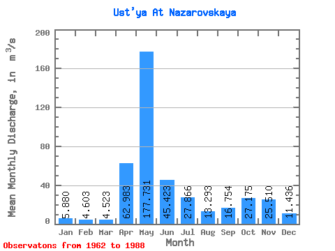
| Statistic | Jan | Feb | Mar | Apr | May | Jun | Jul | Aug | Sep | Oct | Nov | Dec | Annual |
|---|---|---|---|---|---|---|---|---|---|---|---|---|---|
| Mean | 5.88 | 4.60 | 4.52 | 62.98 | 177.73 | 45.42 | 27.87 | 13.29 | 16.75 | 27.18 | 25.51 | 11.44 | 35.26 |
| Standard Deviation | 2.04 | 1.23 | 1.06 | 52.96 | 72.29 | 27.90 | 28.43 | 10.15 | 12.77 | 14.85 | 16.50 | 7.63 | 6.94 |
| Min | 2.79 | 3.05 | 3.18 | 6.02 | 46.30 | 10.40 | 4.73 | 3.60 | 4.13 | 5.98 | 5.84 | 3.77 | 18.23 |
| Max | 11.60 | 7.45 | 7.81 | 190.00 | 309.00 | 148.00 | 113.00 | 39.50 | 48.70 | 58.80 | 69.10 | 37.30 | 50.68 |
| Coefficient of Variation | 0.35 | 0.27 | 0.23 | 0.84 | 0.41 | 0.61 | 1.02 | 0.76 | 0.76 | 0.55 | 0.65 | 0.67 | 0.20 |
 Return to R-Arctic Net Home Page