|
|
|||||||||||||||||
| Point ID: 7429 | Downloads | Plots | Site Data | Code: 70297 |
|
|
|||||||||||||||||
| Download | |
|---|---|
| Site Descriptor Information | Site Time Series Data |
| Link to all available data | |
| View: | Time Series | All |
| Units: | m3/s |
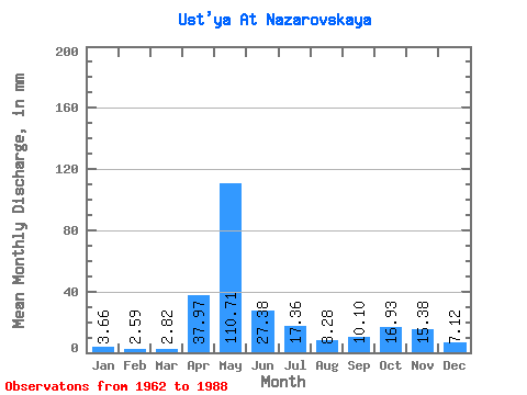
| Statistic | Jan | Feb | Mar | Apr | May | Jun | Jul | Aug | Sep | Oct | Nov | Dec | Annual |
|---|---|---|---|---|---|---|---|---|---|---|---|---|---|
| Mean | 3.66 | 2.61 | 2.82 | 37.97 | 110.69 | 27.38 | 17.36 | 8.28 | 10.10 | 16.92 | 15.38 | 7.12 | 258.82 |
| Standard Deviation | 1.27 | 0.70 | 0.66 | 31.93 | 45.02 | 16.82 | 17.71 | 6.33 | 7.70 | 9.25 | 9.95 | 4.75 | 50.92 |
| Min | 1.74 | 1.73 | 1.98 | 3.63 | 28.84 | 6.27 | 2.95 | 2.24 | 2.49 | 3.72 | 3.52 | 2.35 | 133.76 |
| Max | 7.22 | 4.23 | 4.86 | 114.53 | 192.44 | 89.21 | 70.38 | 24.60 | 29.36 | 36.62 | 41.65 | 23.23 | 371.99 |
| Coefficient of Variation | 0.35 | 0.27 | 0.23 | 0.84 | 0.41 | 0.61 | 1.02 | 0.76 | 0.76 | 0.55 | 0.65 | 0.67 | 0.20 |
 Return to R-Arctic Net Home Page