|
|
|||||||||||||||||
| Point ID: 7426 | Downloads | Plots | Site Data | Code: 70292 |
|
|
|||||||||||||||||
| Download | |
|---|---|
| Site Descriptor Information | Site Time Series Data |
| Link to all available data | |
| View: | Time Series | All |
| Units: | mm |
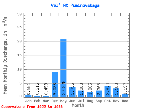
| Statistic | Jan | Feb | Mar | Apr | May | Jun | Jul | Aug | Sep | Oct | Nov | Dec | Annual |
|---|---|---|---|---|---|---|---|---|---|---|---|---|---|
| Mean | 0.68 | 0.52 | 0.46 | 9.03 | 20.58 | 3.76 | 2.38 | 1.81 | 2.37 | 3.87 | 3.18 | 1.20 | 4.15 |
| Standard Deviation | 0.40 | 0.23 | 0.15 | 6.98 | 10.85 | 2.27 | 2.36 | 1.84 | 2.32 | 3.05 | 2.30 | 0.87 | 1.13 |
| Min | 0.25 | 0.23 | 0.23 | 0.82 | 3.65 | 0.95 | 0.49 | 0.36 | 0.45 | 0.54 | 0.38 | 0.32 | 2.63 |
| Max | 2.30 | 1.28 | 0.90 | 27.60 | 49.50 | 10.70 | 9.29 | 8.23 | 10.30 | 11.20 | 8.82 | 4.74 | 6.88 |
| Coefficient of Variation | 0.59 | 0.45 | 0.33 | 0.77 | 0.53 | 0.60 | 0.99 | 1.02 | 0.98 | 0.79 | 0.72 | 0.72 | 0.27 |
 Return to R-Arctic Net Home Page