|
|
|||||||||||||||||
| Point ID: 7426 | Downloads | Plots | Site Data | Code: 70292 |
|
|
|||||||||||||||||
| Download | |
|---|---|
| Site Descriptor Information | Site Time Series Data |
| Link to all available data | |
| View: | Time Series | All |
| Units: | m3/s |
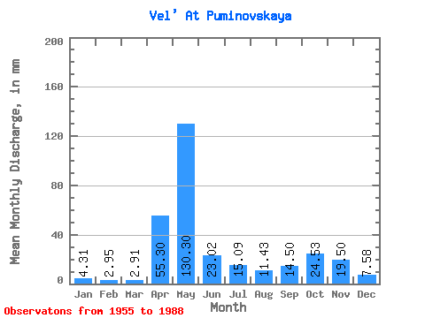
| Statistic | Jan | Feb | Mar | Apr | May | Jun | Jul | Aug | Sep | Oct | Nov | Dec | Annual |
|---|---|---|---|---|---|---|---|---|---|---|---|---|---|
| Mean | 4.31 | 2.97 | 2.91 | 55.30 | 130.28 | 23.02 | 15.09 | 11.43 | 14.50 | 24.53 | 19.50 | 7.58 | 309.75 |
| Standard Deviation | 2.56 | 1.34 | 0.96 | 42.79 | 68.69 | 13.92 | 14.96 | 11.67 | 14.22 | 19.30 | 14.09 | 5.49 | 84.51 |
| Min | 1.58 | 1.33 | 1.46 | 5.03 | 23.11 | 5.82 | 3.10 | 2.28 | 2.76 | 3.42 | 2.33 | 2.03 | 195.91 |
| Max | 14.56 | 7.38 | 5.70 | 169.12 | 313.38 | 65.57 | 58.81 | 52.10 | 63.12 | 70.91 | 54.05 | 30.01 | 513.19 |
| Coefficient of Variation | 0.59 | 0.45 | 0.33 | 0.77 | 0.53 | 0.60 | 0.99 | 1.02 | 0.98 | 0.79 | 0.72 | 0.72 | 0.27 |
 Return to R-Arctic Net Home Page